Monday, 5 August 2013

Crossrail 2 - Cost breakdown

This is the first post in a planned series on Crossrail 2. This one focuses on cost. Specifically, what might be a reasonable breakdown of the headline figures we have.

Cost breakdown

TfL have given us two estimates for the two variants of Crossrail 2 that they are putting forward.

The cheaper option is the Metro scheme, which plans 40tph (trains per hour) of 120m long trains based on DLR type technology. This is costed at £9.4bn (without optimism bias). This proposal can be thought of as a modern tube line, rather than as a Crossrail line in the style of Crossrail 1.

The more expensive option is the Regional scheme, which plans 30tph (trains per hour) of 250m long trains based on Crossrail 1 technology. This is costed at £12bn (without optimism bias)

In order to better offer my own alternatives to these schemes, I found it useful to break down these high level costs to more manageable units. The following is published to allow criticism and comment.

Metro scheme cost breakdown (estimated)

This is my estimated breakdown of the total £9.4bn cost.

Item Cost estimate Rationale
Tunnelling £2,800m 27.9km at £100m per km
Stations £4,400m See below
Depot £800m Estimate
Track, Electrical, Comms £1,000m Extrapolation from Northern line extension
Fees, consultancy £400m Extrapolation from Northern line extension
TOTAL £9.4bn  


Regional scheme cost breakdown (estimated)

This is my estimated breakdown of the total £12bn cost.

Item Cost estimate Rationale
Tunnelling £3,600m 34.4km at £100m per km plus one junction
Stations £4,400m See below
Upgrade Network Rail £1,200m Work needed in Lea Valley and South West
Depot £1,000m Bigger trains than Metro
Track, Electrical, Comms £1,300m More complex signals than Metro
Fees, consultancy £500m Bigger project than Metro
TOTAL £12.0bn  


Station cost (estimated)

I costed the stations up as follows:

StationMetroRegional
Wimbledon£300m£300m
Tooting Broadway£300m£300m
Clapham Junction£500m£500m
Chelsea£300m£300m
Victoria£300m£300m
Piccadilly Circus£400m 
Tottenham Court Road£300m£400m
Euston/St.Pancras£600m£600m
Angel£300m£300m
Dalston£300m£300m
Seven Sisters£300m£300m
Turnpike Lane£300m£300m
Alexandra Palace£200m£200m
Hackney £300m

Summary

The headline figures from TfL are only of limited use, particularly if you are proposing changes. The purpose of this blog is to provide a basis for estimates in other posts.

If you are reading this and thinking that I've forgotten something, or got the cost breakdown greatly wrong, please leave a comment!


Update: Next in the series: Crossrail 2 flaws

Sunday, 24 March 2013

Mole Valley Link

In my last blog I outlined Crossrail SSW, a plan that gains 50% extra train paths on the SWML (South West Main Line) into London Waterloo, fully separating the long-distance, outer suburban and inner suburban services. This blog extends that proposal, making use of the extra capacity to enhance services in the Mole Valley.

Mole Valley Link

The Mole Valley towns of Leatherhead and Dorking do not get an especially good train service. The fastest train from Dorking takes 50 minutes, with neither the route to Waterloo nor the route to Victoria being especially fast. This proposal allows for a faster service, with other knock-on benefits.

The proposal involves constructing a new railway line across open countryside from north of Leatherhead to south of Claygate. The route crosses the M25, A243 and A3, as well as the Prince's Coverts forest. The length of the link is 5.5km.

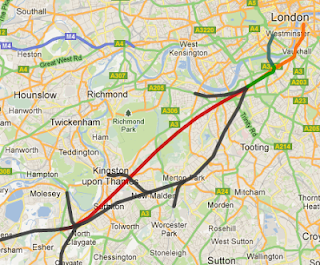
Here is a map of the new link being proposed (click for Google Maps). New link in red, existing lines in black:

Mole Valley Link map

At first glance, the link can seem like a strange choice. The shortest "missing link" in the area is Leatherhead to Chessington South, a link which was planned to be constructed in the past. However, the Chessington link would not have the same benefits as this proposal.

The key point to note from the Crossrail SSW proposal is that the inner suburban service pattern is fully accounted for with Epsom, Chessington, Hampton Court and Kingston (the SWML slow lines). The long-distance service pattern is also fully accounted for (in the new express tunnel from Esher). However, there is still available tph capacity on the outer suburban pair of tracks (the SWML fast lines from Surbiton to Waterloo) as services to Woking and Claygate would not fill the available paths.

Given the available spare paths, clearly the purpose of this proposal is to use some of them, say 4tph (trains per hour) to enhance the Dorking service. But this is only possible if the Dorking trains can reach the fast lines of the SWML before Surbiton. If the link were to go via Chessington, then the additional services would hit Raynes Park on the SWML slow lines, which would defeat the objective of enhancing the Dorking service (and detract from Crossrail 2 generally). By linking Leatherhead to Claygate, the fast Dorking services are able to join the SWML fast lines, exactly as the Guildford via Claygate services would.

In total, the route from Leatherhead to Waterloo is about 1.5km longer via Claygate than via Epsom. But the faster line and fewer station stops would more than compensate. The expected service pattern would be 2tph Dorking, Leatherhead, Surbiton, Wimbledon, Clapham Junction, Waterloo. A journey time of 40 minutes from Dorking should be easily achievable, with 35 minutes being a better target.

In cost terms, building in open countryside should be relatively cheap, however there are crossings of major roads to manage. An initial estimate of £250m seems appropriate (based on the Hitchin flyover at £50m).

Improving the lives of the residents of Dorking and Leatherhead is not, in and of itself, going to be sufficient to justify the link. There are two other factors that should be considered.

Firstly, the link provides much better access from mid-Surrey to the county town of Kingston (accessed via Surbiton). Providing the local links from Surbiton to Kingston town centre are top notch, this could encourage a reduction in the traffic making that journey, especially to shop.

Secondly, and more significantly, the new link can be used to change services from Horsham.

The Horsham connection

The route from Horsham to London (Victoria) via Dorking was the traditional route for services from the Arun valley line (Billingshurst, Arundel, Bognor Regis, Chichester). Over time however, the route became less well used by fast services, with a desire to boost services to Gatwick airport and East Croydon.

Unfortunately, over time, the route via East Croydon has become very full, to the extent that major work will be needed to avoid or enhance East Croydon. Such a project would undoubtably be multi-billion pound. The great thing is that this proposal can step in to be a cheap approach to delay the need for that work.

With the Mole Valley link open, this proposal intends for fast services from Horsham and the Arun Valley to run via Dorking and Surbiton to Waterloo instead of via Gatwick and East Croydon. This would be at least 2tph, and probably 4tph, of additional running between Horsham and Dorking. Horsham would still have services to Gatwick and East Croydon, but they would be slower ones via Redhill (probably Thameslink). There would probably be no direct service from the Arun Valley to Gatwick, at least in the peak.

While Horsham has a long standing link to London Victoria, Waterloo is similarly located for Whitehall jobs and the West End, and cross platform interchange for Victoria at Wimbledon in Crossrail SSW provides for the rest. With this plan, it is intended that there would be no direct fast services from Horsham to Victoria.

The key to this move is that it frees up at least 2tph through East Croydon. Those two paths would be enough to reduce the pressures on the need for a multi-billion pound rebuild there. As such, the £250m of the Mole Valley Link is a real bargain, even allowing another few million to improve the Horsham to Dorking route's line speeds.

Summary

The Mole Valley Link is a 5.5km new railway line from north of Leatherhead to south of Claygate. It allows the Dorking services to join the SWML fast lines at Surbiton, avoiding the slow lines at Raynes Park. By enhancing journey times to Dorking it allows the fast services from the Arun Valley and Horsham to run via Dorking and Surbiton into Waterloo, instead of Victoria.

Benefits are threefold - enhancing journey times to Dorking and Leatherhead (a 10 to 15 minutes saving), better links for mid-Surrey to Kingston, and reducing pressure on East Croydon through the re-routing of the Horsham services.

If you have any views on the Mole Valley Link then why not leave a comment!

Wednesday, 13 February 2013

Crossrail SSW - A better, cheaper Crossrail 2

TfL, London First and Network Rail are starting to put together plans for Crossrail 2. This blog looks at the plans for South West London and an alternative, cheaper, plan - Crossrail SSW.

Update 2015-11-30: This scheme has now been superceded by Crossrail 2 Swirl, which takes the same idea as outlined here and updates it to 2015. Most of the analysis below remains valid, as does the connected Mole Valley Link proposal.

Published proposals

The base set of proposals to compare against come from London First (it appears that TfL are taking the lead behind the scenes). In Central London, the route runs from Euston/St.Pancras/Kings Cross (HS2 and other routes to the North) to Tottenham Court Road (Crossrail 1) to Victoria. This section is relatively uncontroversial.

In South West London, the Crossrail 2 (CR2) plan routes from Victoria to a new stop in Chelsea, then Clapham Junction, Tooting Broadway (Northern line), Wimbledon before surfacing from tunnel. It then takes over services to Epsom, Chessington, Shepperton, Twickenham and Hampton Court.

London First Crossrail 2

The key question is whether this route works for Soth West London? Sadly, there isn't any real detail behind the route maps, so there are more questions than answers.

The biggest question is how will Earlsfield be served? Earlsfield is the station between Wimbledon and Clapham Junction on the South West Main Line (SWML), and is served by the services the plans absorb into CR2. But if those services aren't stopping there, what will? The services remaining on the SWML will be longer distance ones, to Portsmouth and Southampton, and mid-distance ones, semi-fast to Woking and Guildford via Claygate. The semi-fasts currently stop at Earlsfield, but their 4tph (trains per hour) service would be insufficient for Earlsfield's needs (any less than 12tph would not work).

The next biggest question is how many additional fast paths are added? This is important, because the real problem on the SWML is in long-distance services, not the short-distance ones planned to be absorbed by CR2. Network Rail state that the short-distance services could be extended from 8-car trains to 12-car trains and run more frequently to handle overcrowding. By contrast, the long-distance services are already at the maximum number of trains per hour and train length, leaving no options for growth.

The CR2 plans appear to suggest a fifth track between New Malden and Wimbledon, allowing an additional 9tph, or an extra 19% capacity. But this is of dubious value. Squeezing in an additional track (or more sensibly two tracks) is a major task for a working railway, and anyway some of the additional fast trains are going to have to stop at Earlsfield. In addition, it still means that the SWML is operating at absolute maximum capacity with no space for recovery, resulting in unreliable journeys and a general lack of resilience.

Crossrail SSW (Surrey and South West London)

This is a proposal to rearrange the proposals in South West London, providing more capacity for long-distance services, where it is needed and more effective use of existing assets, and all for a lower total cost.

The key task is to address the three distinct flows on the SWML. These are:

  • Inner suburban - services to Epsom, Leatherhead, Dorking, Chessington, Kingston, Shepperton, Twickenham, Hampton Court and slow services to Woking
  • Outer suburban - services to Guildford via Claygate and Woking semi-fast, but conceptually including services to Farnham and Guildford via Woking
  • Long-distance - services to Portsmouth, Basingstoke, Winchester, Southampton, Bournemouth, Weymouth, Salisbury and Exeter

Currently, there are 2 tracks for the inner suburban services and 2 tracks shared between the outer and long-distance services. It is this sharing that causes many of the delays and problems on the SWML.

To separate these three distinct flows, the SSW plan has two distinct parts:

The first part is a new express tunnel from Esher to just east of Clapham Junction. This tunnel would have no stations and be for the use of the long-distance services. As a new, dedicated 2 track tunnel, it would be built to modern standards and be capable of having trains running at 100mph or more, unlike the current SWML which is restricted to 75mph on the fast tracks through London. As such, journey times would be slightly shorter for the long-distance services, perhaps 5 minutes shorter for long-distance services.

The second part is a core London tunnel, similar to CR2, starting from the Clapham Junction area. Since all the long-distance services have been removed from the SWML from Surbiton inwards, the existing 4 tracks between Clapham and Surbiton can be used without conflicts. The outer suburban trains would run on the old SWML fast lines, with the inner suburban services remaining on the slow lines as now.

One key problem any Crossrail 2 type proposal faces is that it will change existing commutes, something which frequently causes a backlash. There are no signs that the official proposal is addressing this. The SSW proposal has a ready-made solution for this. The inner suburban services on the slow lines and the outer suburban services on the fast lines would both stop at Wimbledon, where it is a cross-platform change. Thus, Epsom to Waterloo would still be possible via an easy cross-platform change at Wimbledon. Similarly, Claygate to Victoria would be possible using the same cross-platform change, in the opposite direction.

The tunnel portal for the core London section is the other crucial element in the SSW plan. The Clapham Junction area has vast amounts of railway land and existing tracks. One of these runs from Clapham Junction station down to Longhedge junctions and the site of the new Battersea Northern line extension station. A new interchange station would be built there, providing access to the vast new Nine Elms development, and a secondary route into Waterloo via Northern line (resilience).

Here is a map of the two parts:

Surrey and South West London Solution map

And here is how the services would be separated:

Surrey and South West London Solution map

The CR2 inner suburban routes are in black, the outer suburban routes are in green, and the long-distance in red, going through the new tunnel. In order to balance the frequencies, the Shepperton service is allocated to be outer suburban, swapping between the fast and slow lines at New Malden. This gives Kingston services to both Waterloo and Victoria. The CR2 services to Dorking and Effingham Junction are unfortunate (Epsom or Leatherhead would be a better terminus), but cannot be avoided without an additional project (not discussed here).

The proposed SSW inner suburban 24tph service is as follows:

  • 8tph to Epsom, some continuing to Dorking or Guildford via Effingham Junction
  • 4tph to Chessington South
  • 8tph to Twickenham
  • 4tph to Hampton Court

The proposed SSW outer suburban service is as follows:

  • 4tph to Shepperton via Kingston (total of 12tph London to Kingston)
  • 4tph to Guildford via Claygate
  • 4tph to Guildford via Woking (all stations Surbiton to Guildford)
  • 2tph to Farnham, non-stop or one-stop Surbiton to Woking, then all stops
  • 2tph to Basingstoke, non-stop or one-stop Surbiton to Woking, then all stops
  • up to 8tph additional paths not modelled here

The long-distance services are not explicitly modelled here, however they would cover all existing services that run fast from Waterloo to Woking or beyond. Given that the current timetable is very constrained by lack of available paths, the long-distance services would likely be completely reworked, with up to 24tph available.

The scheme has a number of benefits:

  • 50% more tracks into London than the current SWML allowing 50% more trains, 72tph instead of 48tph
  • Existing commuting patterns are respected, with easy cross-platform change at Wimbledon
  • Much greater resilience if there is a problem, with two virtually independent fast lines, one in tunnel and the existing one above ground
  • Easier access for maintenance, late evening services could use either the tunnel or the old fast line, allowing the other to be maintained from 10pm onwards

And as mentioned as the beginning, the SSW proposal is cheaper than the TfL/London First proposal. They can be compared by examining figures south of Victoria:

ItemTfL planNotes
Tunnelling£1,200m12km (Wimbledon-Victoria) at £100m/km
Wimbledon station£300mDeep tunnelled, links to existing station
Tooting station£300mDeep tunnelled, links to existing station
Clapham Junction station£500mDeep tunnelled, complex links to existing station
Chelsea station£300mDeep tunnelled, expensive part of London
Fifth track£1,000mFifth track in Network Rail RUS ("over £1bn")
TOTAL£3,600m 

Meanwhile the SSW plan has these costs:

ItemSSW planNotes
Tunnelling£1,800m16km (Esher-Clapham) and 2km (Battersea-Victoria)
Battersea station£200mSub-surface reduces costs
Remodel Clapham-Battersea£200mRailway land, relatively simple changes
TOTAL£2,200m 

Thus, the SSW plan is of the order of £1.4bn cheaper than the TfL plan. (As a general rule, tunnelling is cheap, but underground stations are expensive)

The main downside of SSW against TfL is that it does not serve Tooting Broadway, and thus has a far smaller effect on the Northern line. In effect, the SSW proposal reduces benefits to those along the Northern line, and increases benefits to everyone along the SWML beyond Surbiton, as far as Portsmouth, Southampton, Bournemouth and Exeter. This seems like a good trade off, especially given the lower cost. However, given TfL's focus on London, they are unlikely to agree with the trade off.

Summary

The Tfl plan for Crossrail 2 in South West London still lacks details and is thus hard to criticise in depth. However, the intended route is known and the ability of that route to relief the long-distance services (where the real capacity crunch is) can definitely be questioned.

The Crossrail SSW (Surrey and South West London) proposal combines two parts, an express tunnel and a shorter Crossrail 2 tunnel, to produce a scheme that provides far more available train paths at lower cost.

If you have any views on the two proposals - TfL vs SSW - then why not leave a comment!


Update 2013-03-24: The Mole Valley Link is a related proposal that makes full use of the extra capacity of Crossrail SSW to enhance Dorking services and relieve East Croydon.

Friday, 27 July 2012

DLR to Lewisham Junction

In the last few blogs I've argued the case for Lewisham Junction, the development of a major new rail interchange for South East London, backed by regeneration of Lewisham. This blog looks at how the DLR interacts with the site.

Lewisham Junction and the DLR

The Lewisham Junction proposal faces an immediate peoblem in that it acts as less of a junction than the current Lewisham (North) station. This is expected and is the trade off between the inability to further expand the existing site and building a new junction from scratch.

Key to making the new junction work is the DLR.

The first DLR extension would need to be from Lewisham (North) to Lewisham Junction. This would almost certainly be in addition to the existing railway line that runs to Hayes. This extension would be essential to the viability of the station as a junction, especially for connections to Canary Wharf and Stratford.

There has also been talk of extending the DLR, to Catford separate to this proposal. Having been to Ladywell, I'm uncertain as to how that would happen without closing the Hayes line north of Catford. Now this may be a longer term option, but doesn't seem likely now.

Instead, I want to focus on a different DLR extension - from Woolwich. It isn't always appreciated that the DLR station in Woolwich faces west, rather than south. As such, the most logical direction for extension is to the west.

DLR from Woolwich to Lewisham Junction

This proposal would extend the DLR from Woolwich to the new Lewisham Junction station. There would seem to be two main approaches.

The first approach (in purple/red) would see a new tunnel of 2.2 miles from Woolwich to Charlton, probably via the B210 Artillery Place/Hillreach. From there, it would take over the Charlton to Blackheath line from Network Rail, potentially adding a new station by opening up the tunnel near Old Dover Road. From Blackheath to Lewisham Junction, the DLR would then run on the surface alongside or above the existing line to Lewisham before turning to Lewisham Junction. This last section could also be tunnelled.

The second approach (in green) is to tunnel the whole way, running via Blackheath, but not via Charlton. This approach would allow new areas to be served that are currently remote from rail public transport. The amount of tunnelling is of the order of 4.5 miles. Note that the tunnel length is only twice that of the first approach.

The two routes are shown here:

The key benefits of these two DLR extensions is a major boost to public transport connectivity in the area. Lewisham Junction would have direct services to both Canary Wharf and City airport, as well as boosting regeneration in Woolwich.

Summary

The Lewisham Junction proposal cannot work without extending the Lewisham DLR branch to the site. However, the site really starts to work if the Woolwich DLR line is extended to Lewisham Junction as well.

Tuesday, 17 July 2012

Lewisham Junction

Building a key interchange for inner South East London, similar to Stratford or Clapham Junction, would have many benefits to the area. This blog expores a proposal to develop Lewisham Junction as that interchange.

Lewisham Junction

Lewisham Junction is a proposal for a brand new station on a new site on the south side of Lewisham town centre. This blog explains the rationale for the site choice and how it could be developed.

The first thing to note is that Lewisham Junction is a separate site to the current Lewisham station. The current Lewisham station suffers from a complex flat junction and curving platforms, with little room to make alterations. It is not a practical place to expand or convert into a major junction. That said, the existing station, referred to here as Lewisham (North), is already a reasonably major junction, with lines to Victoria & Blackfriars, Charing Cross & Cannon Street, the DLR, Hayes, Chislehurst, Sidcup, Bexleyheath and Charlton.

The Lewisham Junction site is known to the railway as Courthill Loop Junction. To locals, it is to the west of the river at the south end of the High Street. The map hopefully clarifies the location:

This location is closer to the centre of the High Street than the current Lewisham station. And this access could be dramatically improved as part of building the station by opening up the south end of the shopping centre, across Molesworth Street.

While much of the core land is in railway ownership, the access land is not. The southern part of the High Street and Engate Street would ideally be totally redeveloped to provide good access, including for buses.

The station itself would need 4 platforms on the main-line and 2 platforms for the slow lines to Sidcup and Chislehurst. There would also need to be 2 platforms on the Hayes line that runs at right angles to the main-line under the site. (4 platforms are needed on the main-line to allow a train to pull into one platform while another train is pulling out of the other one).

Key to keeping initial costs down would be to no longer provide for trains to run from Hayes to London direct from Ladywell via the "short cut" on the western part of the site. All Hayes trains would have to go via Lewisham (North). Similarly, there would no longer be a connection from Hither Green to Lewisham (North). All Sidcup and Chislehurst services would run "straight on", avoiding Lewisham (North). This change to the services requires that the DLR is extended to Lewisham Junction, so that passengers from Sidcup and Chislehurst can still access Greenwich and Docklands (extending the DLR south of Lewisham North is not simple, but nor is it impossible).

Note that Lewisham (North) would remain open and unaltered with this proposal, serving that area of Lewisham.

Benefits

The real question is what have we gained through this scheme?

The benefits to the railway are simpler operation around the Lewisham area. The Hayes and Sidcup/Chislehurst lines have clearly defined routes/destinations, with less need for complex timetabling. Specifically, there is relief of the Lewisham flat junction, which would allow more Blackheath services. These railway benefits are important, providing a step change in capacity. However, there are much larger benefits around regeneration, with longer term benefits.

Next to this site is Wearside, a Lewisham Council Depot. This is a large plot of land that would suddenly be located next to a key railway junction, with fast access to London. Using this land to drive a major regeneration project would be key to the whole scheme. In addition to the Wearside land, there would need to be concerted effort to completely redevelop the southern end of Lewisham High Street. It would also make sense to redevelop Riverdale House, a nearby office building.

Finally, the main shopping centre would need to be opened up to the south, no doubt providing a major boost to retail in the centre. With the increase in people travelling only by publc transport, and not owning a car at all, improving public transport access to urban shopping centres is of increasing importance.

If these redevelopments could be linked together, there may be a surprising aount of money available to fund the scheme.

Some pictures that may help set the scene.
The southern end of the High Street, station site on the right, ideally replacing this row of shops:

Lewisham, London

Engate Street, behind the High Street. The station site would include this area, requiring demolition of this building and using land further to the right (the High Street is to the left):

Lewisham, London

Wearside depot, targetted for redevelopment:

Lewisham, London

The heart of the site itself, taken here from behind Riverdale House:

Lewisham, London

Longer term

Stratford and Clapham Junction stations are the models that this proposal looks to. Stratford in particular, didn't start as the huge interchange that it is now. Over time, other railway lines came to Stratford, the DLR twice and the London Overground. A key interchange becomes an attractor that reinforces the location.

In future entries I will look at some possible options that would reinforce the "junction" nature of Lewisham Junction, creating the hub for South East London that is needed, but cannot be built at Lewisham (North).

Summary

The current Lewisham (North) station is a reasonable junction, but cannot be expanded. This leaves the Lewisham Junction site, an opportunity for regeneration over a large part of Lewisham town centre and through the Wearside depot to Ladywell. Something that could change Lewisham forever.

South East London interchange

Inner South West London has Clapham Junction as a key interchange. Inner North East London has Stratford. But Inner South East London doesn't have anything that matches the pattern. This blog looks at some of the options.

A key interchange for inner South East London

The key rationale for enhancing and creating key interchanges around central London is to encourage more travellers to avoid the city centre. With the ever increasing number of travellers expected in the next 20 years and limited funds, developing stations and routes outside the centre (like London Overground) look appealing.

Clapham Junction has long been the model of this, recently seeing major growth through London Overground routes around the core city. Stratford is the equivalent in the North East, which has seen major investment for the Olympics and general redevelopment. If HS2 continues, it is likely that Old Oak Common will become a similar junction for the West of London.

Creating a junction of similar scale for South East London is clearly a long-term project, but the connectivity benefits would be huge, for those travelling around the city centre, or between parts of the suburbs. These are the principal location options that I see for building such an interchange:

  • Deptford Park - south of Surrey Quays, where the London Overground crosses the main line to Greenwich, Lewisham and Orpington (Landmann Way)
  • New Cross Gate
  • New Cross
  • Lewisham
  • Lewisham Junction - where the line from Lewisham to Hayes crosses the main line

The key requirements for this site are to be a major junction station, linking networks in different directions. To achieve this requires a large site and main line services as well as local ones. (A junction of only local services doesn't get passengers from outside London routing around the city core). Its also the case that both Stratford and Clapham Junction have major shopping centres nearby, so that should be seen as a good test as well.

Deptford Park is the "obvious" site. It is already a major rail junction, and with suitable investment could have platforms for main-line trains on both the Thameslink East Croydon route and the South Eastern Orpington route, plus London Overground, all the Dartford locals and Hayes. However, Deptford Park is already scheduled for major work as part of London Overground and the Thameslink project, neither of which are building a station. In effect, the ship has sailed here. Furthermore, the site is perhaps too close to London Bridge - certiainly closer in than Stratford or Clapham Junction. There is no development there at the moment, this no major shopping centre or destination for local traffic.

New Cross Gate would be a reasonable option if a new tunnel was built to take all the Dartford locals (via Lewisham). But even then, it misses out on the opportunity to grab South Eastern main-line pasengers before London Bridge. I'm also uncertain that there is enough land there, and there is no major shopping centre.

New Cross is already a junction, but its hard to see what adding more services to it would achieve. There are limitations in available land, and there is no major shopping centre

Lewisham is already a key junction between the DLR and the lines to Blackheath, Hayes and Hither Green. It is however a badly laid out station with a horrendous junction that limits train frequency. The site is near a major shopping centre, although the shopping centre does rather turn its back on the station. It is a site with some ability to grow, but I cannot see how it could become a major junction towards the scale of Clapham Junction or Stratford - there simply isn't the room to add the platforms and sort out the junction.

Lewisham Junction would be a new station located where the Hayes line runs under the South Eastern main-line to Orpington, and where there are links from Hayes to the main-line and from Lewisham to Hither Green. The site is near a major shopping centre (its as close to Lewisham, if not closer, as the current Lewisham station). And the site has lots of land available - there is lots of existing railway land, plus a large council depot right next door.

In practical terms, I suspect that only Deptford Park and Lewisham Junction have the necessary land available to build a suitable large station. But Lewisham Junction wins the prize by being near an existing shopping centre, as well as a large parcel of land that has the potential to be developed (providing cash to find the project).

The next blog will discuss Lewisham Junction in much more detail and what would be needed to make it a key interchange.

Summary

Building a new major rail interchange is not a simple task. Locating it near an existing destination helps provide the initial boost it needs, especially if it enables a major redevelopment project.

Do you have another location where a junction in South East London could go?

Saturday, 7 July 2012

Lewisham station

If you want to get to know an area, perhaps before proposing changes, it is always worth visiting. As such, I recently visited the Lewisham area.

Lewisham station

Lewisham station has four platforms. Platforms 1 and 2 serve the line to Hayes and Hither Green:

Lewisham station, London

Platforms 3 and 4 serve the line to Blackheath:

Lewisham station, London

The definining feature of the station is the flat junction on the London side of the platforms. The junction provides access to Victoria on the left and London Bridge on the right. There is also access to the south side of the main-line to London Bridge from the Victoria route. This junction is a huge constraint to the local rail network, with trains waiting to cross it. (Trains from platform 1/2 are behind me on the left, and from platforms 3/4 behind me on the right):

Junction at Lewisham, London

Junction at Lewisham, London

Junction at Lewisham, London

Finally, the DLR station has been built beneath the main-line station, providing a connection to Greenwich and Docklands.

In a wet rush hour, the trains were fairly full, and occasionally very full, but perhaps a little less busy than those in the South West. The main surprise was the number of travellers taking trains towards Peckham Rye and Victoria, which was many more than I expected. It was also very, very clear as to just how constraining the flat diamond junction is - there was almost always a train waiting to cross it.