The Sutton Link is a proposal by TfL together with the London boroughs of Merton and Sutton for a new high-capacity connection between Sutton town centre and Merton. The link is proposed to use a tram or bus rapid transit (BRT).
TfL's options
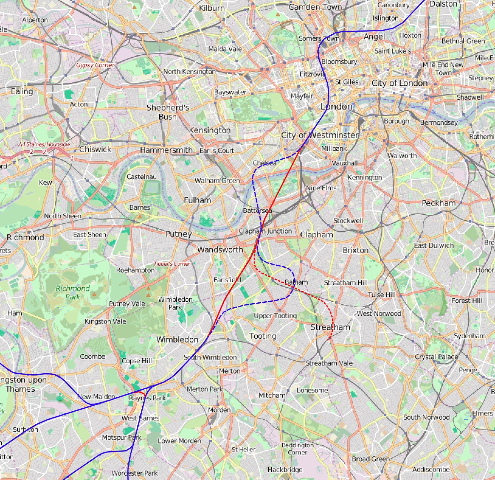
TfL have presented three options to consultation:

Option 1 runs from Sutton to South Wimbledon via Rosehill, avoiding the centre of Morden. Unfortunately, South Wimbledon is not a major destination, so demand on this section is likely to be only for passengers changing to the Northern line. However, the actual terminus is likely to be at Nelson Gardens, a public park 130m short of South Wimbledon tube station (I don't know this for certain, but it is my interpretation of the consultation documents). My opinion is that South Wimbledon is not sufficient a destination to justify the proposed investment. In addition, my view is that not enough passengers would find the interchange to the Northern line at South Wimbledon attractive, nor would they want to use the interchange to the existing tram to travel to Wimbledon. Option 1 is a dud.
Option 2 runs from Sutton to Colliers Wood via Rosehill, totally missing the centre of Morden. While Colliers Wood is a bigger destination than South Wimbledon, it is still not a major destination justifying a tram at this point. The option as a whole simply looks like two separate schemes joined together, with a low likelihood of generating through journeys. Colliers Wood would make sense as a branch of the existing Croydon tram, with services from Colliers Wood to Croydon, but it makes no sense as a route to Sutton. Option 2 is a dud.
Option 3 runs from central Wimbledon to Sutton by taking over most of the existing underutilised railway line. Unlike options 1 and 2, this gets passengers directly into Wimbledon as well as Sutton, providing a key end-to-end link. One of the key success points of the Croydon tram is that passengers use it to travel from Wimbledon to Croydon. Replicating that success will be key to passenger numbers on the Sutton Link, and that means it absolutely must run from central Wimbledon to Sutton. While option 3 is the best of the three TfL options, it fails to reach Rosehill and Angel Hill, which are seen as key destinations for the scheme.
A better choice - option 4
I find all three options presented by TfL to be weak. I struggle to see any of the three generating enough passenger journeys or funding. As such, I present option 4 (in red below), which combines the northern part of option 3 with the southern part of options 1/2, using a novel route to link them:

Here is more detail of the central section:

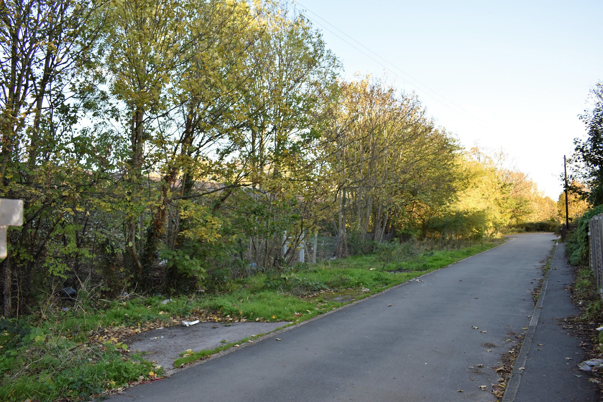
Routes that combined rail and on-street sections were considered and rejected by TfL in their analysis partly because of the difficulty of reaching street level from rail level. Option 4 solves that problem by making the connection alongside Morden Park, where there is plenty of available land and the height difference is minimal. For more pictures, see the photo album. This picture shows the area alongside Morden Park:
Option 4 then continues south down the A24 to Merton College, which is also the site of local leisure facilities. The A24 is a dual carriageway at this point, but this road width is completely unnecessary, so taking half the road for the tram will not be a problem. From there, option 4 follows Green Lane to Rosehill, where it joins the option 1/2 route via Angel Hill to Sutton.
Option 4 has a number of key benefits. Firstly, it serves Merton College and leisure facilities, generating lots of local journeys. Secondly, it serves Rosehill and Angel Hill, which I believe are seen as key to the scheme by TfL and local politicians. Thirdly, it frees up a lot of land.
For completeness, the map includes option 4a and 4b as variants. Option 4a omits Merton College and has a more difficult ramp from rail level to street level. Option 4b avoids Green Lane to serve more of St Helier Avenue. In both cases, my view is that the main option 4 is simpler and more beneficial.
Money
The harsh reality of a scheme like the Sutton Link is that it needs to be funded at a time when TfL finances are hugely stretched. But this part of London is well established and has limited development options (and development is where the money mainly comes from). The main sites earmarked are apparently as Rosehill. But option 4 offers something different to all three TfL options - lots of spare land.
With option 4, the existing railway line from Morden South to West Sutton would close. While not all would be available for development (due to limited access), a large amount would be available. It is the money from developing this land that would, in my view, provide the only realistic funding stream for the whole Sutton Link scheme.
Summary
Option 1 and 2 from TfL would be expensive and unsuccessful. Option 3 is better in that it serves Wimbledon town centre, but doesn't serve Rosehill.
I strongly believe option 4 outlined above is a much better choice. It gets the benefit of a fast, traffic free route into central Wimbledon, while still serving Rosehill and Angel Hill. And it has the key bonus of providing development land suitable for funding the entire scheme.
I encourage you to respond to the consultation before the 6th January 2019 deadline!


